
An Unusual Case of a Divided House: Apollos Clapp[1]
In researching the history of houses, one sometimes finds the division of a house to settle an estate. One heir is given one side of the house, and another heir the other side. This situation occurs along with the division of land, where the line of separation of the land goes through the house separating it into two portions. Then two families occupy the house, keeping to their own sides. [2]
Although division as a result of inheritance was not rare, the division of houses as a result of property seizure for payment of debts seems less common.
Apollos Clap was born in Norton, Massachusetts, on February 27, 1787, a descendant of Thomas Clapp who emigrated from England to Dorchester in the mid 1630s. Unlike other Clap family members, Thomas did not hold on to large tracts of land in Dorchester. He soon moved south to Weymouth, and his descendants spread out to other towns. Apollos was the fifth of eight children in his family and probably did not expect an inheritance.
Apollos Clap acquired his home lot very soon after landowner George Minott decided to have part of his ancestral lands surveyed for sub-division. Surveyor Mather Withington delivered a sub-division plan, dated Jan. 1, 1809, to George Minott, and on Feb. 22, 1809, Minott sold to Apollos Clap the lot that became Clap’s own home. To a young man who would in only a few days reach his 22nd birthday, the Neponset section of Dorchester probably seemed to be an up and coming place in the early 19th century. The town population was growing, and its location not far from Boston and just across the river from Quincy probably would afford opportunities for a house builder.[3]
Until this time the main commercial node in Dorchester was at Lower Mills about 1 1/2 miles west of Neponset (sometimes called Lower Falls) due to the fact that the road from Boston to Plymouth crossed the Neponset River there. The Lower Mills was also the head of the tide and head of commercial shipping for boats on the Neponset River estuary.
A bridge at Neponset Village near the mouth of the estuary had been envisioned for many years, but until the turn of the 19th century, the only means of crossing was by ferry. In the first years of the 19th century, the Neponset Bridge Corporation was formed to construct a span across the mouth of the Neponset. The bridge corporation built the bridge and the turnpike to run from the Lower Road (Adams Street) in Dorchester in a straight line to the Quincy meeting house.[4] Historian and minister Thaddeus Mason Harris mentioned that a “bridge has been built over the river from Squantum by the Quincy turnpike association, and was completed in the year 1803.”[5] The construction of the bridge, providing road access across the river, made Neponset Village a more attractive place for ships to deliver and take on goods. It was not until the late 1830s that Neponset Village received a healthy boost to its commerce, when the Granite Bridge was constructed a little farther upriver, impeding shipping to Lower Mills.
It is probable that Apollos built his own house within a few years.[6] On January 13, 1818, Apollos married Hannah Howe, whose family lived at Neponset. Certainly the house would have been constructed and ready to move into by the time of their marriage.[7] In February he purchased pew 56 in the South Meetinghouse from John Codman, the minister of the church. The distance from Clap’s home to Second Meetinghouse was about the same distance as from his home to the First Church. His choice of Second Church may indicate that he was of conservative Congregationalist views.
In 1812-1813 Second Church was the location of a very bitter and public disagreement between the faction that favored Unitarian principles and those who were staunch in their conservative Congregationalism. After years of meetings and councils, “the crisis came on November 24, 1812, when by a slight majority Mr. Codman was declared dismissed. The minority was so strong, however, that they refused to yield, and on the following Sunday the congregation was presided over by two clergymen.”
In the end, “Mr. Codman and his friends purchased the pews of all who wished to sell them, on the condition that the owners would agree to withdraw from the parish, promising not to interfere with its proceedings thereafter. … The seceders, in 1813, built a new meeting-house, and became a distinct Unitarian parish, under the name of the Third Religious Society.”[8] Clap would have been quite aware of this recent history when he decided to buy a pew.
Apollos was called a carpenter in the family genealogy,[9] a housewright in certain legal documents and a gentleman in others In the second and third decades of the 19th century, he acquired various parcels of land in the Neponset area, including house lots, orchards and marsh. The hay from the marsh and the fruit from the orchards would have produced income to add to his earnings from his work as a carpenter. He bought and sold land; he lent money secured by mortgages. He seems to have had a partnership with Samuel Everett of Milton in the lumber trade.
In the late 1830s Clap borrowed money and gave promissory notes on his own behalf and also through his lumber dealing partnership with Samuel Everett. When Clap did not pay the debts, his creditors sued. Clap lost various parcels of unimproved land and land with buildings in the years 1838 to1839 as the result of thirteen individual court judgments in favor of his creditors. No deed of execution has been found against Everett, so we assume Everett may have disappeared or died or that he did not have any assets to seize. The history of two of the properties include divided ownership of houses. At that time Clap owned the property that is now 361 Neponset Avenue, where he and his family lived. Located on the north side of Chickatawbut Street at the corner of Neponset Avenue, his Federal-style house is still extant. He also owned property on the south side corner of Chickatawbut Street,[10] including a cottage that is no longer existing. The cottage must have been demolished between 1910 and 1918, because it appeared in the Bromley atlas for 1910 but not 1918.[11]
Apollos Clap died in October of 1840, the year after the loss of his property. By the time of his death, he had re-purchased much of the property he had lost. The exception was the house where his family lived for more than twenty years.
The family genealogy described him as “an enterprising and ingenious workman and an honest man.”[12] Could the reason that Apollos was called an honest man have been related to the fact that many of his creditors were satisfied? He re-purchased much of the property taken from him, but he never recovered his own house. Or could the statement in the genealogy have been an attempt to reclaim Apollos’s reputation for future generations by having the last word in print?
At the time Clap was borrowing money, there was no credit reporting agency. Each lender probably did not know that Clap had borrowed from others. It is hard today to imagine lending such relatively large sums without collateral. Yet even without a mortgage document, the promissory note seems to have been enough to obtain judgment.[13]
The following detail from the 1831 map shows the location of the properties set off to Clap’s creditors.[14]
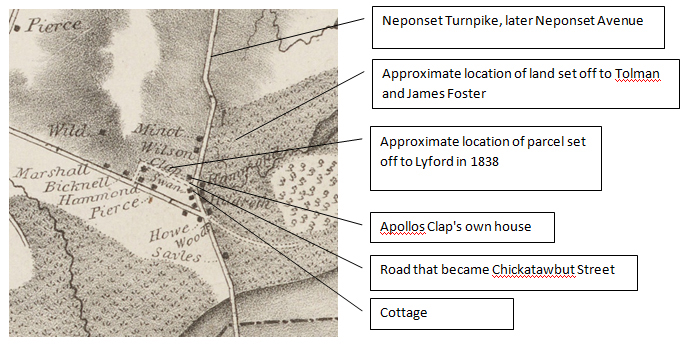
Chickatawbut Street was referred to in the deeds of execution as “the street leading by the Baptist Meeting house” or as “the street running … in a westerly direction to a schoolhouse and a Baptist meeting house.” The position of the church and school in relation to the corner of Neponset Avenue is most easily seen in a detail from the 1850 map of Dorchester.[15] The church is represented by a circle within a circle with a cross, and the school is represented by a circle.

Comments on the legal process.
Each claimant brought suit in the Court of Common Pleas. The suits were carried over from term to term, and most were decided in December, 1838. When Clap did not appear, the court found him in default and issued a judgment instructing the sheriff of the county to seize property of the defendant to satisfy the amount of the debt plus the costs of the suit plus the sheriff’s own costs. The sheriff was commanded to detain the defendant in the county jail until the creditors were satisfied. The sheriff appointed a committee to assess the property of the defendant for the purpose of making an allocation of property to the claimant. The committee made its recommendations for setting off portions of property to each of the claimants, who acknowledged satisfaction, and a deed of execution was recorded. We must assume that Apollos Clap was held in jail from December, 1838, to April, 1839, when the executions were recorded.
Vacant land parcels
Clap lost three parcels of land as follows:
James Lyford, laborer, obtained a judgment from the Norfolk County Court of Common Pleas and a deed of execution, recorded Dec. 25, 1838, for a parcel on the north side of Chickawbut Street.[16] Lyford’s claim was for $368.39 plus $11.70 costs of suit. The value of the parcel set off to him was $393.05, described as a parcel of one acre with an orchard of apple trees with a carpenters shop thereon. Clap regained ownership of this parcel by purchasing it on Nov. 5, 1839 from James Lyford for $401.53.[17]
Stephen Tolman, yeoman, obtained a Judgment for land east of Neponset Avenue, recorded Jan. 11, 1899, for $82.19 plus $16.77 costs, and the deed of execution recorded in April, 1839, described the property as a lot of upland and marsh situated on Neponset Turnpike containing 1 acre and 16 rods and valued at $129.29.[18] Clap regained ownership of this parcel on Jan. 16, 1840, by paying Tolman $109.29.[19]
James Foster, yeoman, obtained a judgment in the amount of $102.14 plus $16.77 costs for a lot of land east of Neponset Avenue on Jan. 11, 1839. In April, the deed of execution setting off the property to Foster described the parcel as a lot of land containing 1acre and 53 rods .[20] Clap regained ownership on Jan. 16, 1840, by paying Foster $129.66.[21]
The Land with the Cottage
There is no indication of the occupancy of the cottage on the south side of Chickatawbut Street prior to the judgments. Apollos and his family were living at 361 Neponset Avenue on the north side of the street. We will leave the discussion of Clap’s home property till the end. After the set-offs to the claimants occurred, the family appears to have been expected to live in a room on the second floor of the cottage across the street from the home where they had been living.
The cottage and its parcel of land were divided. The west portion of the cottage was included in a parcel of 14,300 sq. ft. set off to Asaph Churchill Junior, Esquire.[22] A small part of the land (979 sq. ft.) on the east side was awarded to John Whiting, carpenter.[23] The dividing line passed through the middle of the cottage, allocating the eastern side of the cottage and the 979 sq. ft. to Whiting along with the use of the cellar and the rooms on the lower floor, ” subject however to the right for Asaph Churchill Jr. and his heirs and assigns and to Apollos Clapp his heirs and assigns to pass through the entrys and up the stairs at pleasure to their rooms and nothing more.”
In the deed of execution to Churchill, the wording was “with a right to pass up and down the front stairs and through the front entry of said cottage and thence through the front yard to the front gate and also a right to pass and repass to and from said cottage to the well and to the free use of the same; and the use of small closet opening into the west front room of the cottage and located back of the chimney. The east line of the premises so running as to include within the premises set off to said Churchill the west front room and chamber of the cottage and about the west half of the sheds extending out back of said cottage.”
Churchill received the use of the west front room and the room directly above it. Whiting received the use of the rooms on the first floor on the east side within the bounds of the property set off to him. It appears that the Clap family were left with the back room on the first floor on the west side if there was one. (The mention of the use of the front room by Churchill implies a back room.) Churchill received the use of the room above the west front room, but the use of other rooms on the second floor was not mentioned, presumably leaving them for the use of the Clap family, since the family had the right to pass up and down the stairs.
Apollos Clap regained the property a year later. John Whiting sold the eastern portion of the property to William Pierce on Nov. 5, 1839, for $160.75. Pierce sold the property back to Apollos Clap on Jan. 16, 1840, for $160.00. Clap regained the western portion of the property also on Jan. 16, 1840, by paying $303.82 to Asaph Churchill Jr. [24]
Whiting’s judgment was in the amount of $118.47 plus $19.39 costs. The property set off to him was valued at $154.97. Whiting sold the property for more than he was owed. Churchill’s judgment was in the amount of $259.50 plus $14.18 costs. The property set off to him was valued at $285.63. He sold the property for $303.82. Both men got their money back.
What then happened to Clap’s own house? An Unusual Case of Divided Ownership
In most of the deeds of execution Clap is referred to as a gentleman; in this deed he is referred to as a housewright. Minott’s ancestor, also George, arrived from England in 1633. In 1658 he acquired a dwelling house and 37 acres from John and Sarah Whipple near the River Neponset in Dorchester.[25] Clap was also the descendant of an early Dorchester settler, tracing his lineage to Thomas Clap, who emigrated from England and settled in Dorchester in 1633.[26]
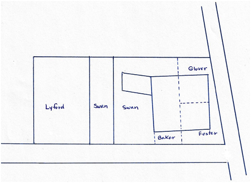
This home property was set off in April, 1839, to James Lyford, Reuben Swan, William Gordon, Jacob Foster, Edmund J. Baker, Benjamin Franklin Glover and Amasa Hunt. The division of land and the house followed a north-south line through the middle of the house and an east-west line dividing the east side of the house into two.
James Lyford received a portion of Clap’s home lot, 7725 square feet of land on the western end of the property.[27]
Reuben Swan, yeoman, received two judgments in his favor. For the satisfaction of one judgment, he received the western portion of the lot where there were no buildings.. For the satisfaction of another judgment he received land including the western portion of the house and an ell extending westward. He received the use of the kitchen and the washroom or back kitchen, the cellar rooms underneath and the rooms above and the attic or garret as well as a shed or woodhouse.[28]
William Gordon, cabinet maker, received no land, but the use of the southwest corner room was set off to him with the right to go in and out of the entry on the south side of the house.[29]
Jacob Foster, housewright, received the southeast corner of the house and the southeast corner of the land including the entry way on the south side of the house and the use of the southeast corner room on the first floor together with a large closet opening into said room on the north of the same and right to pass and repass from the same room through the kitchen of said house this day set off to Rebuen Swan, down the cellar stairs to said Jacob’s portion of the cellar in such direction as shall do the least possible injury to said kitchen[30]
Benjamin Franklin Glover, yeoman received the northeast corner of the land, the northeast corner room in the house and the entry leading toward Neponset Turnpike subject to a right of passage in and out from the dwelling house to said turnpike road of all persons their heirs and assigns to whom we have appraised and set off portions of the same dwelling house this day. He also received the use of a room in the basement directly under the northeast corner of the house with “a right to pass out around said house to the pump back of it over land this day set off to one Reuben Swan.”[31]
Edmund J. Baker, Esquire, received a small portion of land directly in front of the room set off for the use of Gordon, plus Baker received the use of the two second-floor rooms on the south side of the house and the right to pass up and down the stairs and the entry on the east side of the house.[32] He also received the use of the cellar room immediately under the southwest corner of said house set off to Gordon with the right of passage through the kitchen to reach the cellar room.
Amasa Hunt, yeoman, received the use of the northeast corner room on the second floor with a right in said Hunt to pass and repass from said chamber, in and out, down the front stairs, through the front entry of said house and through the front yard to the turnpike.[33]
Divisions of parcels of land. Not to scale.
Cellar rooms set off for use.

First floor rooms set off for use.

Second floor rooms set off for use.

Clap did not re-purchase any of the interests of the claimants to his home property. Again we do not know if any of the creditors paid taxes or other maintenance costs on their real property for the short time they owned it. We do not know if they received any income from the use of any of the rooms of the house.
Benjamin F. Glover, of Dorchester, William Gordon, of Milton and Amasa Hunt, of Canton, sold their interests to Charles H. Minott of New Orleans on July 21, 1841, for $600. [34]
Jacob Foster and Reuben Swan sold their interests to John O. B. Minott, of Dorchester, merchant on April 12, 1843 for $580.
Edmund J. Baker sold his interest to John O.B. Minot, of Dorchester, merchant, April 12, 1843 for $220.[35]
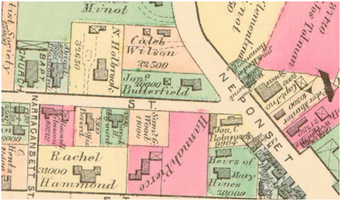
John O.B. Minot sold the whole re-consolidated property to Charles Alden and George N. White on January 31, 1851. They sold the property to Jonathan Butterfield only a few months later on May 21, 1851.
The 1874 map shows the re-consolidated property acquired by Jonathan Butterfield in 1851.
On Oct. 8, 1842, Charles H. Minot sold his interest to J. O. B. Minot.[36]
On Jan. 31, 1851, John O. B. Minot sold the re-consolidated property to Charles Alden and George N. White.[37]
On May 21, 1851, Charles Alden and George N. White sold the property to Jonathan Butterfield.[38]
Summary of Judgments against Apollos Clap

It appears that almost everyone other than Jacob Foster and Reuben Swan received their money back or nearly so. Foster and Swan had judgments adding up to over $1,000. They sold their interests for $580.00. One wonders what their motivation was. Their interests were valued by the appraisers at higher amounts than Foster and Swan were owed. Other men made their money back, so the valuations appear to be fair. Why were Foster and Swan willing to let go of their interests for half of the value?
In the months between the setting off and the re-sale of the properties, we do not know if any of the men who shared in the cottage or the family home needed to pay expenses on the properties such as real estate taxes or maintenance.[39] Also we do not know if any of them may have rented out their portions of the house or received income in any other way from the property. Based on what little we do know, we can say that the creditors generally seem to have been made whole.
Architectural characteristics of 361 Neponset Avenue
Visual observation
The house at 361 Neponset Avenue is a Federal-style house. The east side has a 5-bay appearance, and the south side has a 3-bay appearance. The house was built on a slightly mounded lot. It has 2 chimneys, one on the north and one on the south. There is an ell extending from the northwest corner of the house. There is an enclosed porch/entry probably dating from the 20th century on the east side of the house.
Presumptions:
The floor plan of the house probably was like other Federal-style houses with four rooms on each floor; each room was roughly square in shape.
The chimney on the north side of the house would have had fireplaces on either side on both the first and second floors to serve the northwest and northeast rooms. The chimney on the south side of the house would have had fireplaces on either side on both the first and second floors to serve the southwest and southeast rooms.
The entry on the south side of the house would have had doors to the southwest and southeast rooms on the first floor. The entry hall would have ended at the chimney. The southwest and southeast rooms would each have had a door allowing access to the north side of the house.
What do the deeds tell us about the house?
It had a lightning rod
There were four rooms on each floor
The cellar was divided into rooms
The only entry to the basement was through the kitchen.
Reuben Swan received the use of the kitchen along with some other rooms. “Said kitchen however subject to be passed through by E. J. Baker, B. F. Glover, Jacob Foster and their heirs and assigns each and severally in going to their respective parts of the cellar under the sd house”
The house had two entries. The one on the east side was considered the main entry.
The entry hallway on the east side of the house toward the turnpike had a set of set of stairs to the 2nd floor
Benjamin Franklin Glover received the northeast corner room on the first floor and the entry hall leading to the front door on the east side subject to a right of passage in and out from the dwelling house to said turnpike road of all persons their heirs and assigns to whom we have appraised and set off portions of the same dwelling house this day.
Edmund J. Baker received the use of the two chambers on the southerly half of the dwelling house on Neponset being the two chambers over the room s set off to William Gordon and Jacob Foster together with a right to pass and repass to and from said chambers down the front stairs through the front entry out of the front door on the east side of house to the turnpike over land this day set off to B. F. Glover
and
Amasa Hunt received the use of the “chamber or room on the second floor in the north east corner of the dwelling house of said Clapp, now occupied by his family, situated on the turnpike Dorchester near Neponset Bridge, being the chamber immediately over the room or apartment this day set off to Benjamin F. Glover together with aright in said Hunt to pass and repass from said chamber, in and out, down the front stairs, through the front entry of said house and through the front yard to the turnpike.”
The entry on the south side of the house allowed access to the southwest and southeast rooms on the first floor.
The entry hallway on the south side was set off to Jacob Foster along with the room on the southeast corner, but William Gordon, who received the first-floor room on the southwest corner, had “a right pass and repass through and over said entry way out of said room and over the past from the South door of the house to the street leading from the house to the Baptist meeting house.”
There must have been a back stairway from the first floor kitchen to the chamber above. Reuben Swan received the washroom or back kitchen and the kitchen with the rooms above and the garret, but he was not specifically mentioned as receiving the right to pass up and down the stairway in the east hallway.
There was a lookout or observatory at the top of the house
There were two closets or pantries in the kitchen
There was a garret or attic
There was a washroom or back kitchen and a cistern, possibly in the ell.
There was an outbuilding called a shed or woodhouse
Note:
Court Cases
Not all court cases could be found in the records of the Court of Common Pleas records at the Massachusetts Archives.
Whiting’s case in the Suffolk Court of Common Pleas in 1838 was not found.
The other cases were entered at the Norfolk County Court of Common Pleas.
Only one of Lyford’s cases could be found.
All the rest followed the same pattern. Clap had given a note in return for money, and he later did not pay when due. Suit was brought and carried over for several terms of the Court. Then, when Clapp did not show up in December, 1838, he was in default. Judgment was pronounced.
[1] A portion of this article appears on the Dorchester Historical Society’s blog. Posted Jan. 26, 2020. http://www.dorchesterhistoricalsociety.org/blog/?p=3791
[2] One example occurred in the history of the 17th-century James Blake House in Dorchester. Descendant John Blake died March 2, 1717/18. Surviving heirs included his wife Hannah, sons John and Josiah and daughters Hanna and Elizabeth. They all agreed that Hannah, the mother, would have life rights to the estate and that John and Josiah would receive the entire real property upon her death or re-marriage. At that time, the sons would pay cash to their sisters for their shares in the estate. In the meantime the sisters were allowed to live in a room in the house. A division plan dated April 22, 1748, shows that each brother received a side of the house. The house remained in divided ownership until 1832. During the intervening years each side had been deeded outside the Blake family. Plan of land belonging to John Blake and heirs of Josiah Blake, April 22, 1748. Subdivision map at Dorchester Historical Society. Also Edward Zimmer. “The James Blake House: A Documentary Study.” Architecture in Colonial Massachusetts. (Boston,: Colonial Society, 1979), 61-74. He references Suffolk County Probate Records XXI, 555.
[3] An analysis of Dorchester Births, Marriages and Deaths to the End of 1825. (Boston, 1890) reveals that the population of Dorchester increased from 1722 to 2347, a 36% increase, in the last decade of the 18th century, and in the first decade of the 19th century, it was on pace to add another 584 residents, a 25% increase. For a general description of the Neponset Village area of Dorchester, see the Neponset VillageArea Form prepared for the Boston Landmarks Commission as part of 1994 Survey of Dorchester. Dated March, 1995, and recorded by Edward W. Gordon.
[4] Wood, Frederic J. Turnpikes of New England. (Boston, 1919), 100-101.
[5] Harris, Thaddeus Mason. Chronological and Topographical Account of Dorchester.(Boston, 1804), 19. William Samuel Pattee. A History of Old Braintree and Quincy: With a Sketch of Randolph and Holbrook. (Quincy, 1878), 68-71. Acts and Laws of the Commonwealth of Massachusetts, 1802-1803. Volume 12. ( Boston, 1898), 79.
[6] Norfolk County Registry of Deeds. Book 34, Folio 134. The Dorchester tax assessor’s records at the City Archives are not specific enough to be helpful in dating the construction. The large increase in value between 1812 and 1818 may indicate that Apollos’ property was improved with a house during that period. Tax assessment records are not available for 1813-1817. The Federal style of the house confirms that it may have been built in the 18- teens.
[7] Massachusetts Town and Vital Records on Ancestry.com Original data: Town and City Clerks of Massachusetts. Massachusetts Vital and Town Records. Provo, UT: Holbrook Research Institute (Jay and Delene Holbrook). https://search.ancestry.com/cgi-bin/sse.dll?indiv=1&dbid=2495&h=69381086&tid=&pid=&usePUB=true&_phsrc=UdT3879&_phstart=successSource
[8] Orcutt, William Dana. Good Old Dorchester, A Narrative History of the Town, 1630-1893. (Cambridge, 1893), 253-259. See also American Unitarianism, 1805–1865. Edited by Conrad Edick Wright. Boston: The Massachusetts Historical Society and Northeastern University Press, 1989. The Memorial of the Proprietors of the New South Meeting-House in Dorchester, to the Ministers of the Boston Association. Together with Their Report on the Same. (Boston, 1813). Proceedings of the Second Church and Parish in Dorchester; Exhibited in a Collection ofPpapers. 2nd ed. (Boston, 1812). Review of Two Pamphlets, Which Were Published on the Subject of the Ecclesiastical Controversy in Dorchester. (Boston, 1814). Reprint from the Panoplist and Missionary Magazine, vol. 10 (1814), 256-281, 289-397. Wright, Conrad. The Unitarian Controversy. Essays on American Unitarian History. (1994).
[9] Ebenezer Clapp. The Clapp Memorial. Record of the Clapp Family in America. (Boston, 1876), 155.
[10] A Record of the Streets, Alleys, Places, Etc., in the City of Boston. (Boston: City of Boston, 1910), 111, 331. Chickatawbut Street was not named until 1853. Neponset Avenue was originally the Neponset Turnkpike or the Quincy Turnpike leading across the Neponset River to Quincy. See also Frederick J.Wood. Turnpikes of New England. (Boston, 1919), 100-101.
[11] G. W. Bromley & Co. Atlas of the City of Boston: Dorchester, Mass. (Philadelphia, 1910), plate 33 and
Atlas of the City of Boston: Dorchester. (Philadelphia, 1918), plate 33.
[12] Clapp, 155.
[13] Norfolk County. Court of Common Pleas. 1838. Record book and case files. These are located at the Massachusetts Archives. The deeds reference below include verbatim the case file notes. The case files in addition contain original promissory notes and itemized expenses of the court and sheriff. Only once for Lyford was found, although the deeds reference two. Whiting brought his case in the Suffolk County Court of Common Pleas, but that file was not found.
[14] Edmund J. Baker. A Map of the Towns of Dorchester and Milton. 1831.
[15] Elbridge Whiting for S. Dwight Eaton (Old Colony R.R. Depot, Boston). Map of Dorchester, Mass. 1850.
[16] Norfolk County Registry of Deeds. Book 121, Folio 240
[17] Norfolk County Registry of Deeds. Book 125, Folio 162
[18] Norfolk County Registry of Deeds. Book 123, Folio 168
[19] Norfolk County Registry of Deeds. Book 125, Folio 246
[20] Norfolk County Registry of Deeds. Book 123, Folio 169
[21] Norfolk County Registry of Deeds. Book 125, Folio 246
[22] Norfolk County Registry of Deeds. Book 123, Folio 66. See alos D. Hamilton Hurd. History of Norfolk County, Massachusetts. (Philadelphia, 1884), p. 21. Asaph Churchill Jr. was an attorney and counsellor, born in Milton, April 20, 1814; graduated Harvard College in 1831; studied law with his father in Milton and in the Harvard Law School; admitted to the bar before he was 21years of age and had an office at the Lower Mills in Dorchester.
[23] Norfolk County Registry of Deeds. Book 123, Folio 28
[24] Deed from Whiting to Pierce Norfolk County Book 125 Folio 162 ; deed from Pierce to Clap Norfolk Registry of Deeds. Book 125, Folio 245.
[25] Robert Charles Anderson. The Great Migration Begins. (Boston, 1995), v. 2, 1267.
[26] Ebenezer Clapp. The Clapp Memorial. Record of the Clapp Family in America. (Boston, 1876), 105.
[27] Norfolk County Registry of Deeds. Book 123, Folio 67.
[28] Norfolk County Registry of Deeds. Book 123, Folio 70.
[29] Norfolk County Registry of Deeds. Book 123, Folio 72.
[30] Norfolk County Registry of Deeds. Book 123, Folio 74.
[31] Norfolk County Registry of Deeds. Book 123, Folio 71.
[32] Norfolk County Registry of Deeds. Book 123, Folio 76.
[33] Norfolk County Registry of Deeds. Book 123, Folio 78.
[34] Norfolk County Registry of Deeds. Book 131, Folio 190.
[35] Norfolk County Registry of Deeds. Book 139, Folio 301.
[36] Norfolk County Registry of Deeds, Book 137, Folio 256
[37] Norfolk County Registry of Deeds, Book 199, Folio 81
[38] Norfolk County Registry of Deeds, Book 201, Folio 281
[39] Tax assessment records are not available for the period 1839-1843.