Building 1: 200-204 Columbia Road (ca. 1900-1904)
This three-story light gray brick building was owned by Elizabeth MacQuarrie in 1904 and 1910, and sold in 1918 to Lillian Donohue. The building is unlike most of the neighboring apartment buildings with a smooth rounded corner, high cast stone watertable, and an unbroken dentil cornice at the roofline. Two entrances on Columbia Road with arched surrounds provide access to the apartments.
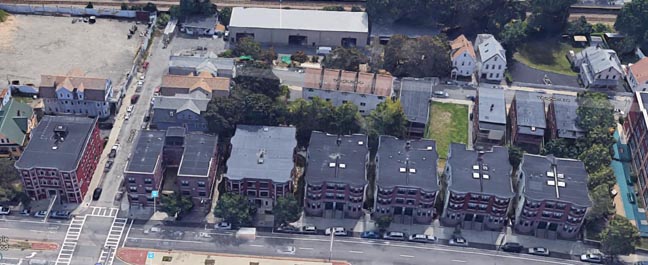
Building 2: 193-195 Columbia Road (ca. 1905-1910)
This three-story brick apartment building was owned by Isadore and Esther Cohen in 1910 and the Boston Penny Savings Bank by 1918. The façade has projecting elliptical end bays, two central entrance doors, and a decorative dentil cornice. It is identical to the apartment buildings next door at 197-199 Columbia Road, 203-205 Columbia Road, and 209-211 Columbia Road.
Building 3: 197-199 Columbia Road (ca. 1905-1910)
This three-story brick apartment building was owned by Rosa Ginsberg in 1910 and Fanny Waxer by 1918. The façade has projecting elliptical end bays, two central entrance doors, and a decorative dentil cornice. It is identical to the apartment buildings next door at 193-195 Columbia Road, 209-211 Columbia Road, and 203-205 Columbia Road.
Building 4: 203-205 Columbia Road (ca. 1905-1910)
This three-story brick apartment building was owned by L. Silverman and D. Gelman in 1910 and Morris Hurwitz by 1918. The façade has projecting elliptical end bays, two central entrance doors, and a decorative dentil cornice. It is identical to the apartment buildings next door at 193-195 Columbia Road, 197-199 Columbia Road, and 209-211 Columbia Road.
Building 5: 209-211 Columbia Road (ca. 1905-1910)
This three-story brick apartment building was owned by L. Silverman and D. Gelman in 1910 and Louis Paeff by 1918. The façade has projecting elliptical end bays, two central entrance doors, and a decorative dentil cornice. It is identical to the apartment building next door at 193-195 Columbia Road, 197-199 Columbia Road, and 203-205 Columbia Road.
Building 6: 217-219 Columbia Road (ca. 1905-1910)
This three-story plus basement brick apartment building at 217 Columbia Road was constructed circa 1909. The building was owned by the Rubenstein Family in 1910 and in 1918. The first story of the Columbia Road (north) elevation is clad with cast stone and has a central entrance framed with pilasters and Tuscan columns. The two outer bays of the north elevation are canted and finished at the corners with cast stone quoins. The north (façade) elevation features an ornate ogee-profiled projecting cornice with decorative modillions and dentils.
Building 7: 223-225 Columbia Road — “Wales Court” (ca. 1905-1910)
This three-story U-shaped brick building was owned by the Trustees of William Q. Wales in 1910 and 1918. It has a landing at the center of the courtyard that leads to an entrance at each wing of the building. The building features minimal ornamental detail aside from cast concrete string-courses or banding. A tall brick parapet may have originally held a decorative cornice.
Building 8: 229-231 Columbia Road — “Parkway” (ca. 1905-1910)
This three-story brick apartment building was owned by F.T. Manson in 1910 and Myer Rubenstein in 1918. The façade has projecting end bays, a central entrance with recessed door, and cast stone quoins at every edge in the building.
The Columbia Road — Devon Historic District is a collection of eight residential apartment buildings constructed roughly between the years 1900 and 1910 in the Dorchester neighborhood of Boston, Massachusetts, during the height of the area’s rapidly booming transportation corridor along Columbia Road. The district is significant under National Register Criterion A for its association with the development of Dorchester and neighboring Roxbury following the expansion of the streetcar system and the transformation of Columbia Road into a boulevard and a vital transportation artery. This group of buildings was constructed by speculative builders in direct response to the transformation of Columbia Road. The district is additionally significant under Criterion C for its architecture, as the group of buildings forms a distinctive collection of residential complexes built by speculative builders along Columbia Road. The district contains examples of the brick apartment building forms found throughout Dorchester and are excellent examples of the transition from early triple-decker apartment buildings to a more modern Colonial Revival form during the first half of the twentieth century.
The period of significance for the Columbia Road — Devon Historic District ranges from 1900, when the first contributing building is thought to be constructed, and 1964, the fifty-year cut off date for historical
significance. All contributing resources continue to serve in their original function as apartment buildings to this day. The proposed district retains its integrity of location, association, feeling, setting, design, workmanship, and materials and is visually distinct from the surrounding earlier wood-frame construction.
Narrative Statement of Significance (Provide at least one paragraph for each area of significance.)
History of Dorchester & the Rise of Boston’s Jewish Population
The historic Dorchester neighborhood, a dissolved municipality and largest neighborhood in Boston to date, was founded just a few short months before the city of Boston in 1630. At the time of Dorchester’s annexation into Boston on January 4, 1870, the rural town of 12,000 located five miles south of Boston’s city center remained primarily undeveloped. Dorchester borders Roxbury to the west with boundaries that are somewhat indeterminate, occupying approximately six square miles along Dorchester Bay and the lower Neponset River.
During the second half of the nineteenth century, Boston experienced a period of prosperity that transformed it from a merchant city with a population of 200,000 persons to an industrial metropolis with a population of more than one million. The physical form of the city changed from a compact seaport to a metropolitan area sprawling ten miles from Boston City Hall, encompassing thirty-one cities and towns throughout eastern Massachusetts. The old Boston settlement of 1850 became the industrial, commercial, and communications center of the 1900 metropolis. The old settlement filled with tenement apartments, which, in addition to the existing residential building stock, housed the lower income half of the population. In its transition, Boston was encircled with an outer ring of middle-class and upper-income settlement, which by 1900, was primarily occupied by those commuting into downtown Boston for work. The street railway system along with a corresponding expansion of city services fostered these outer rings of settlement.’
Concurrent with the expansion of transportation routes from downtown Boston to suburban areas during the latter part of the nineteenth century, Dorchester experienced many changes. The extension and improvement of horse car service in the 1870s and 1880s facilitated commuting between Dorchester and Boston and fostered Dorchester’s transformation into a middle-class suburb. By the late 1880s and 1890s, the streetcar routes were both expanded and electrified, spurring a rapid rate of building development and settlement in this once rural community. Railroad corridors running along Dorchester Bay and Mattapan with local transit service from Roxbury and South Boston to Bowdoin and Fields Corner, helped expedite the rate of expansion by making Dorchester a highly desirable commuter community. Between 1870 and 1900, the population of Dorchester dramatically increased from 12,000 to 80,000.2 With the expansion of the electric trolley lines came the development of the three-decker apartment buildings to accommodate the ever-growing dense, urban population. The Bellevue-Columbia Road area was considered a “status area” due to its exceptional rate of growth during the early- to mid-twentieth century.’
According to The Jews of Boston, “Between 1880 and 1914, more than 90,000 Jews informed immigration officials in ports across the United States that their final destination was Massachusetts.”4 Although less than half of them remained in the state, the Boston neighborhoods of Dorchester, Roxbury, and Mattapan were home to the second largest Jewish population in the United States during the twentieth century. A majority of Jewish immigrants, typically a literate male with a skilled trade accompanied by an illiterate wife and children, came from Russia. The first wave of immigrants settled near the Polish and German populations on Boston’s South End, but by the 1890s, they began expanding to better areas of the city. Chelsea became home to the growing Jewish population as well as neighborhoods on the North and West Ends of Boston. From 1892 to 1917, the more successful Jews expanded into Dorchester and Roxbury from Boston’s downtown. What was originally a small movement of the more elite Jewish population became a mass exodus by 1918. The Chelsea Fire of 1908 also contributed to a large number of Jews relocating to the “streetcar suburbs.”
With the rising number of Orthodox Jews living in Boston in the late nineteenth century came the demand for Jewish-specific businesses, including Kosher shops. These businesses “filled the Jewish districts of Boston, especially in the North and West Ends, and later the Blue Hill Avenue district of Roxbury and Dorchester.”5 Other Jewish immigrants worked in textile and shoe industries or as independent peddlers, small retailers, and second-hand clothes dealers. The majority of Boston’s Jews, including women, earned moderate wages and did not fit the elite profile of the select Jewish bankers, manufacturers, and large business owners.
Dorchester was a hotbed for social activism and reform during the turn of the twentieth century, including home to the first racially integrated neighborhood on Jones Hill and birthplace of the Niagara Movement, precursor of the National Association for the Advancement of Colored People (NAACP). Despite the seemingly quick changes to come in Dorchester, education remained a valuable asset of the Jewish culture. In 1920, the Bureau of Jewish Education was established and the Hebrew Teachers College was reorganized and settled in a permanent home in Roxbury in 1921. Synagogues and meeting houses were also an important aspect of the Jewish social culture. By 1918, five major synagogues were serving the Boston Jewish population, one of which was located in Brookline, and the other four located in the Roxbury and Dorchester areas.6 The Crawford Street Synagogue in Roxbury, for instance, was the center of life for the quickly growing suburb in the 1920s with a congregation of 500 families. The suburb also had an active Sisterhood, Men’s Club, and Junior Council. Likewise, the Hecht Neighborhood House (160 Legion Highway) in Dorchester, served as a central meeting place and social club for the Roxbury and Dorchester Jewish community throughout the 1930s, 40s, and 50s.7
By the mid-1920s, many middle- and upper-middle-class Jews began to leave Roxbury, Dorchester, and Mattapan for the nearby Boston suburbs, especially Brookline. As Gerald Gamm notes in his book Urban Exodus, the conditions in towns like Brookline and Newton, recreated “the rural ideal that had brought an earlier generation of suburbanites to upper Roxbury and Dorchester. Suburban homes were a refuge from the busyness and hustle of urban life.” 8 Two additional factors spurred the migration to Brookline and Newton: the rise of the automobile and federal housing programs of the 1930s. The automobile allowed people to commute into the city from increasingly distant residential areas, freeing those that could afford a car from dependency on streetcar routes.9 Federal housing programs in the 1930s contributed to the exodus by actively guiding middle-class homeowners away from urban housing and toward single-family suburban homes.’° Although the population of Roxbury and Dorchester increased sixteen percent between 1920 and 1930, the populations of Brookline and Newton increased twenty-six and forty-two percent respectively during the same period. Leadership of the Boston Jewish population was relatively responsive in addressing the needs of the Jews left behind during the shift in population. They set up a multi-service center for assistance and were able to provide needed funds. As it is quoted in The Jews of Boston, “The Jews of Roxbury, Dorchester, and Mattapan fared better than those in similar circumstances in many other American cities.””
The racial demographic of Dorchester changed in the 1950s and 1960s from Jewish and Irish Americans, to a growing number of African Americans moving from the South to the North during the Great Migration. The area became the center of civil rights activism into the 1950s, including home to Martin Luther King, Jr. throughout the duration of his PhD studies at Boston University. “White flight” was a prevalent concern as many Jewish Americans relocated to the growing suburbs and an influx of new immigrants from Ireland, French Canada, and Italy as well as migrant African Americans continued to populate the area. A majority of the newly arriving African American population began settling in the Blue Hill Avenue section of Dorchester, which, by 1980, became a predominately black community.
Extension of Transportation Routes and Services to Dorchester, 1830-1900
The establishment of new technology in transportation was a major component in fostering development outside of major city centers. Suburban growth followed the circulation patterns of the railroad, allowing easy access of manufactured goods and raw materials to previously remote locations. In 1830, the Baltimore and Ohio Railroad introduced the first steam-powered railroad engine in the United States known as the Tom Thumb locomotive. The introduction of this new technology spurred rapid growth of the railroad industry with new lines expanding westward from major northeastern cities. By the time of the Civil War (1861-1865), an extensive network of railroads connecting major cities existed in the eastern portion of the United States reaching as far west as Chicago. Looking for new sources of revenue, railroad companies began building passenger stations along already established routes. Towns centered on these stations grew as speculative developers purchased and subdivided land around these stations, establishing semi-rural residential communities.12
These early railroad towns, or suburbs, offered an escape from the city to upper and upper-middle class citizens. Historian John Stilgoe referred to the location of such early suburbs as the “borderland;” a place where the city and its modern amenities met the countryside. The railroad provided suburban residents access to the city’s downtown, while simultaneously insulating these new communities from the lower middle and working class residents that could not afford the cost of commuting. By the mid-1860s, railroad commuting was well established around cities such as Philadelphia, New York, Chicago, San Francisco, and Boston. In fact, Boston had eighty-three commuter stations situated within a fifteen-mile radius of the city center as early as 1850.13
In the 1830s, the horse-drawn car, or horsecar, revolutionized cross-city travel. With this new mode of transportation, horse drawn cars could now run along two parallel iron or steel rails, known as tramways, set in the street for a smoother more favorable mode of transportation then the already established omnibus system. Operating as a local version of the stagecoach line, the horsecar service offered regularly scheduled stops on a fixed route making it the first version of the modern public transit system in the United States. In addition to Boston, these systems operated in New York, Baltimore, Philadelphia, Pittsburg, Chicago, Cincinnati, and Montreal by 1860. Their routes followed existing transportation paths radiating from city centers toward the emerging railroad towns or suburbs.’4 With the increasingly efficient public transit options, city perimeters began to expand during the 1850s. The new systems increased the distance a person could commute in a half hour from two miles to three miles, enlarging the amount of land desirable for residential development from thirteen to almost thirty square miles from the city center.15
By 1865, the early horse omnibus network that connected Boston to Dorchester was entirely replaced with the more efficient horsecar system. The improved transportation network fostered residential development outside Boston, which during the 1860s, extended an additional half-mile from the city center. By the time of the 1873 depression, rapid development had resulted in a concentrated population stretching two-and-a-half miles from Boston’s City Hall. Horsecar service continued to expand following the end of the depression in 1879 to meet the needs of transportation outside of Boston’s densely populated core. By 1887, another mile-and-a-half of extended service now provided reliable and efficient transportation within a four-mile radius of City Hal1.16 The northern portion of Dorchester, situated within a three-mile radius of City Hall, now became an accessible prime location for residential development by the last decades of the nineteenth century.
The large-scale development of suburban land required not just reliable and efficient transportation but also sanitation and power services considered a necessity for the standard house by the last third of the nineteenth century. Prior to the 1870s, cities and towns within the Boston metropolitan region had relied on a combination of public and private agencies for water and sanitation services. This mixture of public and private services provided only partial coverage for the metropolis and did nothing to curb the periodic plagues and epidemics that had swept the city beginning in the seventeenth century. “By 1870,” according to historian Sam Bass Warner, “Boston’s own efforts and other American and European sanitary projects showed that the incidence of disease could be effectively reduced by thoroughgoing sanitary engineering.”17
During the last three decades of the nineteenth century, sanitary projects in Boston consisting of waterworks, sewer lines, land filling, and re-grading, consumed approximately one-third of the city’s budget. The initial expenditure of water mains, reservoirs, pumping stations, and trunk sewers were required to be paid for by a pledge of municipal and state credit. Homeowners played their part by installing their own plumbing, while water meters and special installation assessments covered operating costs. Historically, public interest in water supply issues were of greater concern than the city’s waste disposal systems, leading to the establishment of two separate programs that remained under different management throughout the nineteenth century. Sanitary engineering projects were becoming highly popular at the time and received strong public support fostering large expenditures on aggressive planning works. In fact, Warner notes in his book, Streetcar Suburbs: The Process of Growth in Boston (1870-1900), “as fast as new street railway transportation brought new houses to outlying parts of the city the sanitary departments hastened to provide facilities.”18
Once street railways and sanitary engineering opened outlying areas to residential development, the lesser utilities including gas, electricity, and telephone service sought out new customers often targeting the highest paying customers first then expanding as profits dictated. These utilities were developed by private companies and did not need to provide service to the entire city. They provided convenience and efficiency, which “gave private companies marketable products for which users would pay the whole cost.”19 Gas service began to expand in the 1840s followed by electricity and telephones in the 1890s. These three utilities were derivative of the expansion of transportation lines and sanitary and water works.
With the establishment of railroad lines and horsecar routes, transportation began to influence the geography of social and economic classes. Middle and working class residents lived closer to the city center in neighborhoods with horsecar service, while the upper and upper-middle class residents had the financial means to live farther out in in the newly developed railroad suburbs.2°
Establishment of the Electric Streetcar
While the establishment of horsecar service initiated settlement outside the city center, the introduction of the electric streetcar ushered in an unprecedented rate of suburbanization. The first electric streetcar, or trolley system, was introduced in Richmond, Virginia, in 1887 by Frank J. Sprague. The speed of the electric streetcar transformed a thirty-minute walk into a ten-minute ride. The system was quickly adopted nationwide with 5,783 miles of streetcar track by 1890, rapidly increasing to 34,404 miles of track across the country by 1907. In older cities like Boston, the electric streetcar replaced the horsecar system allowing the transportation lines to extend further out making more land available for residential development. Growth generally first occurred in the outlying rural villages interconnected by streetcar lines and then along the new residential corridors established by the streetcar routes.21
By offering a low flat fare and free transfers, the streetcar altered the socioeconomic make-up of suburban settlement. The affordability of this new form of transportation attracted a wide range of individuals from the working class to the upper-middle class, with the largest population of settlers in streetcar suburbs falling within the middle-class. The low fare of the streetcars encouraged households to move to the suburban periphery where land and new housing cost less.22 Unlike railroad suburbs that formed around rail stations, streetcar suburbs formed continuous corridors of development due to their higher frequency of stops within shorter intervals. In most cities, the development of real estate strongly followed the establishment of streetcar lines. When purchasing land along new routes, developers generally platted rectilinear subdivisions of small lots where dwellings were no more than a five- or ten-minute walk to the streetcar line. Multiple story apartment buildings and commercial interests such as grocery stores, drug stores, and bakeries, tended to cluster at the intersection of streetcar lines or along the more heavily traveled routes.23
In Dorchester, this trend is illustrated with the clusters of brick apartment buildings developed on Columbia Road near the streetcar line during the turn of the twentieth century when streetcars were the
primary mode of transportation. The 1899 Boston Elevated Railway System Map depicts a surface line that provided access to Columbia Road with stops at Dudley Street and Geneva Road. The line ran along Bowdoin Street just east of Columbia Road, whose widening and expansion began circa 1897. The intersections at Geneva Road and Columbia Road and Dudley Street and Columbia Road became important transportation hubs, while adjacent land became prime for the development of apartment buildings.
Columbia Road Improvement Project
During the 1870s and 1880s, many industrialized cities such as Boston began to invest in parks, parkways, and boulevards. Following the precedent set in New York City with the establishment of Central Park in 1858, many cities funded green space initiatives with the goal of improving the quality of life for urban dwellers through open space, natural scenery, and outdoor recreation. In cities such as Boston, Buffalo, Brooklyn, and Louisville, parkways and boulevards were established to connect the parks with the city centers. These parkways and boulevards were extensions of park carriage roads and characterized as wide, tree-lined roadways that often ran alongside streams and brooks. They became increasingly desirable corridors for the development of neighborhoods and suburban estates for the upper and upper-middle classes.24
In 1875, the city of Boston authorized a park system comprised of municipal and metropolitan segments. The park system, known as the Emerald Necklace, was originally conceived as “a common ground stretching from the heart of the city to the more rural scenery of the suburbs.”25 Frederick Law Olmstead designed and oversaw its construction, which began in 1879. Implementation of the design faced many obstacles and required a great deal of labor, money, and land. The system, once completed, provided “an environment of charming scenery and healthful resort for the pleasure and benefit of both urban and suburban populations of Boston and its municipalities.”26
Franklin Park, once known as West Roxbury Park due to its location in Roxbury and Jamaica Plain, was the last and largest component of Olmstead’s Emerald Necklace. The park consists of 527 acres with six miles of roads and fifteen miles of pedestrian and bridal paths. The area currently features a zoo, the Long Crouch Woods, athletic areas, a playhouse, picnic areas, and Schoolmaster Hill. Franklin Park also features the William J. Devine Golf Course designed by Donald Ross (1872-1948), which remains the second oldest public course in the United States. In 1879, park commissioners looked to secure present-day Franklin Park for the municipal system. A report released by the commission stated:
[Franklin Park] would rank as the chief park of the city by reason of its extent, its fine landscape and scenery, its superb views and its central situation; it possesses every element of genuine park scenery within its limits, admirably disposed of in their relation to each other; broad, open copses, picturesque glens, covered with tangled undergrowth, and an ample supply of water from springs and brooks for ornamental use.27
Franklin Park, completed in 1885, became the jewel of Boston’s twelve-mile chain of parks and boulevards and was referred to by the Boston Globe as “the great rural rendezvous of the municipal system.“28
Columbia Road, beginning as a narrow and modest country road, was widened and expanded in September 1897 to serve as a major thoroughfare connecting the series of parks in Olmstead’s Emerald Necklace. The Board of Street Commissioners approved widening the road, which originated opposite Franklin Park on Blue Hill Avenue and extended to Boston Street, to 110 feet. Following construction, the extended Columbia Road known as Columbia Street before its expansion, would connect Franklin and Marine parks. The Boston Globe reported on the project days before work began, stating that the new Columbia Road would “complete the magnificent chain of parkways which now (sic) encircles the city […] it will be a magnificent boulevard, and over the greater portion of it the electric cars will run.” 29 Another article in the Boston Globe noted, “This improvement will prove a notable one, from the fact the street is used as much as any in Dorchester, and is now destined to be one of the prominent thoroughfares in this part of the city.”3° The work on Columbia Road was the largest and most expensive undertaking in Dorchester up to that time with total land damages for takings associated with widening the street alone exceeding $500,000.
Construction of Apartment Buildings Along Columbia Road
The widening and extending of Columbia Road had a substantial effect on the value of property fronting the boulevard. The project spurred many property owners to put large tracts of previously undeveloped land up for sale. 31 Although initial development in the area had favored the construction of single family houses, development opportunities stemming from the Columbia Road improvement project led to a substantial increase in the construction of multi-family housing. As reported in the Boston Globe:
It is not necessary to go into any detailed statement of the condition of the real estate market in Dorchester during the past year, as the activity, which has been manifest in this section for the past few years, continued during 1905. At the present time it is to the interest of the home buyer to state that many properties are being sold here at prices within the reach of not only the middle classes, but also the masses, many small houses having been constructed and finding a ready market. The number of apartment houses that have been erected in Dorchester the past year demonstrates the fact that also people are now turning to this class of house that in previous years were satisfied with single dwellings. The claim is that the numerous improvements, such as heat, hot water, and janitor service, are responsible for this state of affairs.32
The article went on to report that apartments along Columbia Road offered good rental prices, were rented quickly, and were occupied by the best quality of tenants.
Although buildings permits for the eight brick apartment buildings that comprise the proposed Columbia Road – Devon Historic District were not on file at Boston Inspectional Services, they exhibit similar forms and architectural detailing indicative of the speculative, repetitive building described by Warner in Streetcar Suburbs. Bromley Atlases from 1889, 1904, and 1918 illustrate the distinct development along Columbia Road and the immediate surrounding area. In 1889, the Bromley Atlas depicts a minimal level of residential development along Columbia Road with a mixture of large tracts and smaller more urban lots developed with single and twin houses. By and large, this section of Dorchester remained generally undeveloped at this time. By 1904, the atlas shows an increasing number of smaller residential lots as the larger tracts were sold to speculative builders. Scores of wood-frame residential buildings were constructed on the east side of the New York and New England Railroad. The sale of large tracts allowed the establishment of new roads to connect Columbia Road and Blue Hill Avenue, which were developed with wood-frame residential buildings on small lots. The southern cluster of apartments, outlined in the proposed Columbia Road — Devon Historic District, sit on a tract that was owned by the trustees of William 0. Wales before its development through 1904. The tract fronted Columbia Road and extended east to Olney Street. Four small lots along Columbia Road adjacent to the Atherton School had been subdivided from the Wales tract and developed with a wood-frame building and three small brick structures. A handful of residential lots had also been delineated at the northern end of the Wales tract, also fronting Columbia Road.
Early residential construction in Dorchester followed architectural trends prevalent in other Boston neighborhoods such as the Back Bay where rows of townhouses were executed in the then-fashionable architectural styles of Italianate, Colonial Revival, Queen Anne, and Richardsonian Romanesque. The popular bow-front form, appearing on many of the single-family homes throughout Dorchester, also referenced trends found in the concurrently developing Back Bay townhouses.35 The wood-frame, single-family homes, in turn, influenced the design of apartment buildings that began to appear at the turn of the twentieth century following the expansion and improvement of Columbia Road. Lots that were not infilled with single-family homes were sold to developers seeking to capitalize on the area’s growing popularity. The construction of a number of new apartment buildings quickly began on the open parcels of land along Columbia Road to accommodate the growing population.
The Bromley Atlas from 1918 shows much of the area laid out in its current configuration with long, built-up rows of brick apartment buildings along Columbia Road. The portion of the William Wales tract on the west side of the New York New Haven and Hartford Railroad was sold and developed between 1904 and 1918. In 1908, Elizabeth W. Little et al purchased a portion of the tract along Columbia Road. The sale was reported in the Boston Globe, which noted that the title went through Frederic M. McIntire and that the property was to be improved.36The majority of buildings bound by the New York and New England Railroad, Grove Street, Blue Hill Avenue, and Geneva Avenue were of wood-frame construction; the most common building material in central Massachusetts for residential properties. Brick construction was generally limited to religious, civic, and commercial buildings, a handful of which are depicted on the map near the intersection of Blue Hill and Geneva avenues, where they were used as support for the streetcar system. These freestanding apartment buildings often emulated the nearby single-family homes in scale and overall appearance. Likewise, the designs of the apartment buildings often borrowed architectural elements such as Colonial Revival detailing and the bow front form and were closely massed with small strips of land between the individual buildings.
Changes in the housing form of an area often signaled the arrival of a different set of builders. As Warner notes in Streetcar Suburbs, “years between substantial shifts in transportation or architectural style neighborhoods continued building in uniform patterns.”37 The row of brick buildings constructed along Columbia Road at its intersection with Geneva Avenue were among the first brick residential buildings constructed south of Columbia Square east of Blue Hill Avenue, signaling a change in the speculative builders active in the vicinity, a shift in architectural styling, and transformations in the transportation system. Buildings located in this concentrated area exemplify the practice of speculative, repetitive building in Dorchester during the last decades of the nineteenth century and first decades of the twentieth century. Speculative builders, who often limited their operations to one or two architectural styles within a specific price range, were responsible for residential buildings that exhibit the same or similar architectural forms and detailing. Generally speaking, it has been concluded “Once a builder had learned a successful land-house combination he stuck to it until fashion forced him to abandon it. If the area he worked in shifted its character, so that his kind of operation was no longer the popular one, he usually preferred to move to new land rather than to vary his house and land style.”38 The brick apartment buildings were also a departure from the wood-frame single- and twin-homes and triple-deckers that were previously constructed in the area.
The 1910 federal census shows residents of these apartment buildings shortly after construction housed a mix of first- and second-generation immigrants from Europe as well as a handful of well-established working-class American families. A significant number of Russian Jewish families are represented but were not the majority of the initial residential population in these buildings. By 1920, the federal census shows nearly every apartment in this stretch of Columbia Road housed first- or second-generation Russian immigrants whose native language was Yiddish. This overwhelming demographic majority continues into the 1930s and 1940s with few exceptions, as indicated in the federal census records. It was not unusual to have members of different cultural groups including English and Irish immigrants, residing within the same building. During the early twentieth century, many of these residents worked retail and office jobs, while a few held positions in the area’s industrial market.
Colonial Revival Style
Architecturally, all buildings encompassed within the proposed Columbia Road — Devon Historic District feature detailing evocative of the Colonial Revival style with varying levels of ornamentation; a style at the peak of its popularity during the district’s period of development. The evolution of the Colonial
Revival style can be seen along Columbia Road as development continued east to west during the first half of the twentieth century. The apartment buildings within the proposed district, dating from the first decade of the 1900s, display characteristics favorable of early triple-decker apartment design including simplistic Colonial Revival style influences. As development continued, a shift to a more modern Colonial Revival form took place, as depicted in the development moving west on Columbia Road. Apartment building along Columbia Road generally features detailing such as stamped metal cornices, stone lintels, and stone door surrounds. The most common ornamentation is decorative brickwork trim along the base of the cornice, quoins of either brick or stone, and medallions featuring either flora or the name of the apartment building.
The Colonial Revival style, drawing heavily on American Georgian and English Adam inspired precedents, remained highly popular in the United States from 1880 to 1955. Its single-most defining characteristic is an emphasis on the door surround of the main entrance, which often features pilasters supporting a pediment or entablature as seen in the Georgian-style, or a fanlight above the door as seen in the Adam-style.39 Four principle characteristics define the Colonial Revival style and include accentuated front doors with pilasters supporting pediments or one-story one-bay entry porches, fanlights and sidelights framing the entrance, symmetrical fenestration on the façade, and multi-pane double-hung sash windows commonly featured in pairs. Variations in the style can produce one, two, or three story structures with side gable, hipped, or gambrel roofs reflecting of the Dutch Colonial style influence. Some Colonial Revival dwellings have asymmetrical façade while others feature a second-story jetty reminiscent of post-medieval English structures. The style is commonly found not just in the design of single-family dwellings, but also multi-family structures such as twin dwellings, triple-deckers, and brick apartment buildings. The enduring popularity of the Colonial Revival style explains its pervasive use by speculative builders in the development of the surrounding area. Although relatively simplistic in design, examples of ornate, Colonial Revival-style entrances featuring ornamental pilasters, pediments, or brackets are found on the residential buildings within the district. The contributing buildings are symmetrical and regularly fenestrated with a focal point on the main entrance, whi